
Avalanche Deaths a Tragic Part of Mount Washington History
By Peter Crane, Curator, Gladys Brooks Memorial Library | June 15, 2021
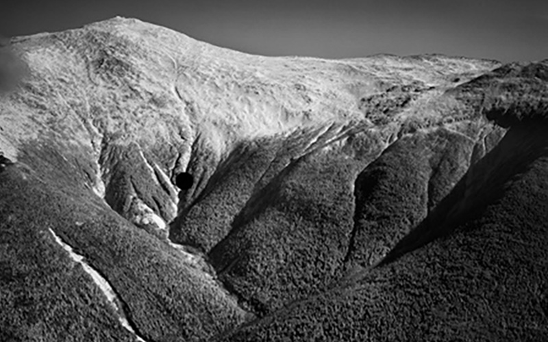
Mount Washington and Ammonoosuc Ravine (looking from the west). The large dot marks the approximate site of the Forgays tragedy. Bradford Washburn photo.
On Monday February 1, 2021, an avalanche in Ammonoosuc Ravine took the life of Ian Forgays, 54, of Lincoln, Vermont.
Forgays, a very experienced backcountry skier, was skiing alone in this ravine on the western side of Mount Washington. Weather conditions were favorable with the temperature in the single numbers and teens and winds averaging 33 miles per hour that day. The Mount Washington Avalanche Center had issued a “low” rating for avalanche danger, but it is important to under-stand that low hazard does not mean no hazard, and even when such hazard is minimal, it is not unusual for areas of unstable snow to exist in some locations. As the Center’s forecast for the day stated, “the potential for small avalanches of wind drifted snow remains in isolated areas at mid and upper elevations.”
Presumably Forgays skied onto such an unstable pocket, which released and carried him downward. To compound his predicament, the spot lay in a “terrain trap” — an area where a broader slope of snow could slide downward into a tighter, funnel-like constriction, resulting in relatively shallow snow piling up into a deep mass over the skier. This was a mass from which he could not escape; new snowfall the next day, with a subsequent avalanche, buried him only deeper.
Friends of Forgays alerted authorities to his absence late Tuesday. On Wednesday, a full field search commenced, focused on Ammonoosuc Ravine. Forgays had been using an avalanche transceiver, or beacon—a small device that sends out an electronic homing signal which can be received by another such device—which was essential in locating him. His signal was acquired at about 4:30 p.m.; it would take more than an hour and a half to dig through almost 13 feet of avalanche debris to reach him. By then Ian Forgays had succumbed to asphyxiation.
The search and recovery effort included personnel from the New Hampshire Fish and Game Department, the White Mountain National Forest/Mount Washington Avalanche Center, and the all-volunteer Mountain Rescue Service.
The Mount Washington Avalanche Center issued a detailed incident report, assessing the snow conditions and considering the decisions made by Forgays. The Center noted that Forgays was a very capable and accomplished skier, and such skiers, honed by experience, sometimes accept calculated risks. Unusual circumstances can cause those calculations to go awry, to the adventurer’s peril. In this case, the Center stated, “skiing technical lines, in a thin snowpack above a notorious terrain trap, with no partners, even on a Low danger day, raises the stakes tremendously.” We send our condolences to Forgays’ family and friends.
According to available records, 17 people have died in avalanche incidents on Mount Washington; this number does not include others who have been caught, buried, or injured by such snow slides on the mountain and who have lived to tell the tale.
The first two people who died in an avalanche-related incident on Mount Washington were Philip Longnecker, 25, and Jacques Parysko, 23, who died in January of 1954 while camping in an igloo-like snow shelter built imprudently just beneath the Tuckerman headwall. Their shelter was hit by a small snow slide, burying Longnecker and leading Parysko to attempt an escape by hiking ill-prepared down the Sherburne Ski Trail, where he succumbed to hypothermia.
Another early avalanche victim was Aaron Leve, 28, who was hiking in Tuckerman Ravine in February of 1956. He was with four others who were struck by the snow slide—indeed one probably triggered it—but he alone was fully buried, and it took an extensive effort to locate his by-then-lifeless body.
Following those incidents, it seems that all such tragedies involved either skiers or climbers—the latter including technical ice climbers as well as non-technical winter climbers on Lion Head.
As noted earlier, Ian Forgays, 54, died in an avalanche in Ammonoosuc Ravine in February of this year. His was the first such incident on that side of the mountain. Perhaps surprisingly, no skier has yet died in an avalanche in Tuckerman Ravine. Three skiers have died in such incidents in the aptly-named Gulf of Slides— John Wald, 35, and his companion Todd Crumbaker, 29, in one avalanche in March of 1996, and David McPhedran, 42, in January 2000. More recently, Nicholas Benedix, 32, died in an avalanche in April 2019 while skiing down the Ravine of Raymond Cataract, a not-so-often skied route lying on the east side of the mountain, between Tuckerman Ravine and Huntington Ravine.
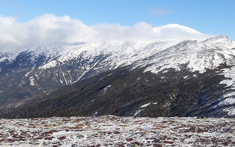
Mount Washington from the east (from atop Wildcat “D” peak). The summit of Mount Washington is in the clouds, as is so often the case. From left to right can be seen the Gulf of Slides, Tuckerman Ravine, the Ravine of Raymond Cataract, and Huntington Ravine, each of which has been the scene of one or more avalanche fatalities.
Mountaineers venturing onto the steep slopes of Huntington Ravine, favored by technical ice climbers, have come to grief when unstable snow perched precariously in that precipitous terrain has overcome them. In February 1964, Hugo Stadtmüeller, 28, and John Griffin, 39, lost their lives as a result of such a snow slide. Thomas Smith, 41, succumbed to an avalanche in Huntington in February 1991; his climbing companion was injured but survived. Peter Roux in January 2018, and Jimmy Watts, 24, in March 2013, were solo climbers who died as a result of avalanches in this ravine.
In early winter it is not unusual for ice climbers to ply their craft on the headwall of Tuckerman Ravine, and two such climbers, Scott Sandberg, 32, and Thomas Burke, 46, in separate parties, were lost to an avalanche in November of 2002, in an incident that involved seven individuals.
The slopes of Lion Head, one of the standard not-so-technical routes for winter ascent of Mount Washington, have been the scene of avalanche tragedies as well. In January 1982, Albert Dow, 28, a volunteer from the Mountain Rescue Service, lost his life while serving in the search for two missing climbers. In January 1996, Alexandre Cassan, 19, died while attempting an ascent of the mountain via Lion Head.
Of Mount Washington’s avalanche toll, five were skiers, seven were technical climbers, and five were non-technical climbers or hikers. All were male. The average age of the victims was 33, with a range from 19 to 54. Two deaths occurred in November, none in December, six in January, three in February, three in March and three in April. All of these people were on the mountain for a day of enjoyment, to indulge their passion for recreating in the outdoors and rising to mountain challenges, but it was a day from which they never returned.
For those with an interest in exploring Mount Washington, or other such mountains, in winter and spring, avalanche knowledge can be a prerequisite for safe adventures. Especially if you have an enthusiasm for skiing the steeps, or climbing challenging slopes, taking an avalanche safety course should be on your to-do list. Many climbing schools or guide services offer such instruction, from basic awareness sessions to detailed technical courses in snow science and rescue coordination. Even with such training under your belt, sometimes “a little knowledge can be a dangerous thing,” and humility and acknowledgement of what you don’t know about the complicated subject of avalanches should remain a guiding principle. (Renowned Swiss guide André Roch once reminded a group of his colleagues, “It is good you are all experts. But the avalanche, it does not know that you are experts!”) Check, and strive to understand and abide by, the avalanche forecasts issued by the Mount Washington Avalanche Center. Don’t just take a look at those forecasts once in a while—read them daily through the winter, to further enhance your understanding of the evolution of the snowpack and its potential hazards throughout the snow season. Pack along “the holy trinity” of avalanche safety tools —beacon, probe, and shovel —and practice their use, realizing that speed in use of a beacon can literally mean the difference between life and death. And always remember that alluring as the powder or ice or summit may be, the mountain will be there for another day.
The waves of avalanche snow have been compared to ocean waves, in their power, but also in their tragic impact. Indeed, it should never be forgotten that, “The snowy torrents are like the deep sea: they seldom return their victims alive.”

Seek the Peak Spotlight: The Cloud Chasers
Seek the Peak Spotlight: The Cloud Chasers By MWOBS Staff Mike Bergeron and Desiree Bolton have been participating and volunteering for Seek the Peak for three years now. Together, they comprise Team Cloud Chasers

Celebrating 250 Years: The Declaration’s Legacy in the White Mountains
Celebrating 250 Years: The Declaration's Legacy in the White Mountains By Peter Crane We are now approaching July Fourth, Independence Day, the day when we celebrate the adoption of the Declaration of Independence in

Seek the Peak Spotlight: Ryan Shepard
Seek the Peak Spotlight: Ryan Shepard By MWOBS Staff Before Ryan Shepard moved to Conway, he was in Western New York celebrating his 40th birthday party. “I wanted to go big,” he said. “Big”
